Falls to Hotham Alpine Crossing, Backpack 3 days grade 4, 37KM.


 Length: 38.5km
- Duration: 3 days
- Grade: 4
- Style: One Way.
- Meet: 8am Mount Loch carpark, Mount Hotham, Fri 27 October. Car pooling to be pre organised to Mt Loch. Snow Dog Transport leaving at 8.30am from Mt Loch to Falls creek start point, $80 per person.
-
Start: (After transfer) Heathy Spur carpark, Falls Creek.
-
End: Mt Loch carpark at Mt Hotham.
-
Closest Town: Falls Creek
-
Location: Alpine National Park
-
Distance from state capital: 388km
-
State: VIC
-
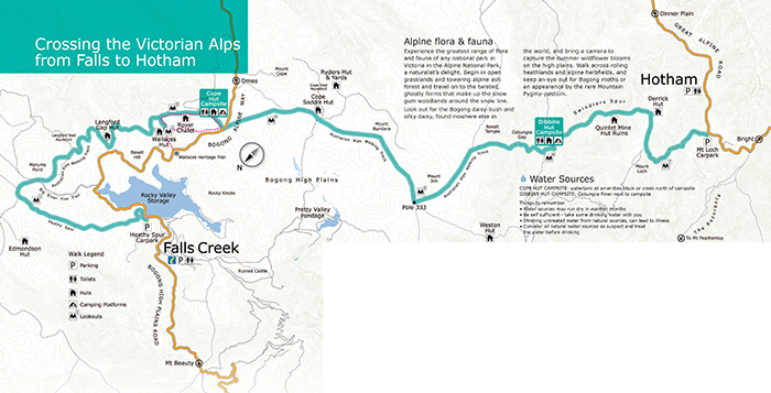
The 37km Falls-Hotham Alpine Crossing (FHAC) is a 3 day / 2 night walk through the Alpine National Park from Falls Creek to Mt Hotham.
Summary
One of Victoria’s icon hikes, the 37km Falls to Hotham Alpine Crossing is a 3 day / 2 night walk through the Alpine National Park, linking the resort villages of Falls Creek and Mt Hotham.
Winding its way along alpine ridges through snow gum woodlands and snow grass plains, over rocky summits and past historic huts, this 3 day hike offers an achievable and rewarding hiking challenge with spectacular views every step of the way.The Falls to Hotham Alpine Crossing is a point-to-point walk. The track can be walked in either direction but is best when starting from Falls Creek and walking towards Mt Hotham.
From Falls Creek the trail starts from the Heathy Spur carpark, on the eastern side of the Rocky Valley dam wall in the Alpine National Park. Heathy Spur carpark is 3km from the Falls Creek Information Centre via road, or walk from the Falls Creek village bowl via the aquaduct track. The trail finishes at the Mt Loch carpark at Mt Hotham.
There are two campsites on the Falls to Hotham Alpine Crossing,
Cope Hut campsite, amongst the Snow Gums on the Bogong High Plains, is 14km from the trailhead and usually the first night’s campsite.
Dibbins Hut campsite, on a snow plain near the headwaters of the Cobungra River, is 9km from Mount Hotham.
Getting there
From Falls Creek the trail starts from the Heathy Spur carpark, on the eastern side of the Rocky Valley dam wall in the Alpine National Park. Heathy Spur carpark is 3km from the Falls Creek Information Centre via road, or walk from the Falls Creek village bowl via the aquaduct track. The trail finishes at the Mt Loch carpark at Mt Hotham.
Day 1: Falls Creek to Cope Hut (14 kilometres)
Start at the Heathy Spur car park, three kilometres from the Falls Creek Information Centre, and trek up to Heathy Spur and the Big River Fire Trail. Climb past Marums Point, then follow the track along the Langford East Aquaduct with views of Shannonvale and across to Mt Wills. Meet the Wallace Heritage Trail to see heritage-listed Wallace Hut before pitching your tent for the night at Cope Hut.
Day 2: Cope Hut to Dibbins Hut (14 kilometres)
Walk through grassy alpine meadows, skirting the base of Mt Cope to Cope Saddle Hut and the Cope East Aqueduct. Continue across the High Plains to reach Pole 333 – the junction of four walking tracks. Journey south and behold awe-inspiring views of Mt Feathertop (1922m). Steady yourself for the steep descent through Cobungra Gap, before taking the short walk down to Dibbins Hut to claim your camping platform.
Day 3: Dibbins Hut to Hotham (9 kilometres)
Test your mettle with a steep climb up Swindlers Spur, take in stunning views of Mt Feathertop, across the Bogong High Plains and Basalt Temple, and pass the abandoned Quintet Mine site. Surge ahead to the top of Swindlers Spur, passing charming weatherboard Derrick's Hut, and enjoy an even ramble past Mt Loch to the finish line at Mt Loch car park.
There are two Falls to Hotham Alpine Crossing campsites – Cope Hut campsite on the Bogong High Plains and Dibbins Hut campsite near the headwaters of the Cobungra River.
CAMPSITE FACILITIES
facility Cope Hut - platforms,Toilet, Water (untreated), Picnic table, Hut for emergency shelter, Fireplace
Dibbins Hut Tent platforms - platforms,Toilet, Water (untreated), Picnic table, Hut for emergency shelter, Fireplace
TENT PLATFORMS
How do I use the tent platforms? Each campsite has four 3m x 3.7m standard platforms and one larger platform that is 4.5m x 3m. It is suggested that the 4 standard tent platforms at each site can fit one 2-3 person hiking tent.
Tents can be erected on the tent platforms at the Falls to Hotham Alpine Crossing campsites for a small cost. There is free camping 100m away from the tent platforms.
The tent platforms are designed for you to pitch your tent directly on the platform. Each platform has eyelets around the edge to hook tent peg loops or guyropes over. As well as these there are movable ‘pegs’ that slot into the mesh, allowing tents of all shapes to be set up.
To safely use your hiking stove, please use your stove on the metal heat shield located in the corner of each platform.
WATER
Is there water available along the walk? Water is available at both campsites. These water sources are untreated. Use with caution and if unsure treat the water to make it safe to drink. For more information about treating water, refer to the Water - Make it Safe to Drink parknote, on the Parks Victoria website.
Cope Hut campsite There is a watertank attached to the toilet, however supply cannot be guaranteed. Water can also be collected from the creek just north of the campsite.
Dibbins Hut campsite Water can be collected from the Cobungra River, next to the campsite.
MOBILE PHONE COVERAGE
Will I have mobile phone coverage on the walk? Mobile phone reception will be intermittent along the walk. Telstra coverage is generally good across the Bogong High Plains and poorer when dropping down into Dibbins Hut.
Download Booklet for more information
EVENT GRADINGS - GRADE 4
WHAT TO BRING for overnight walking in the Alps
Overnight Event Packing list
Current Medical Information Form LOGIN FIRST and then it can be FOUND ON THE WEBSITE HERE
- Tent (sharing sections of the tent with a partner is an option)
- Tent footprint (optional but recommended)
- Sleeping Bag rated to -5 comfort level minimum
- Sleeping bag Liner
- Mattress
- Pillow
- Bed Clothing (suggest using your thermals for bedding)
- Thermals - top and bottom
- Second layer - top and bottom
- Spare dry socks and spare undies
- Keep clothing in a water tight bag - zip lock - dry bags etc..
- Rain jacket
- Down jacket
- Fleece jacket
- Warm Gloves and Water Proof Over Glove plus a beanie
- Suitable walk hat
- Boots in good condition
- Essential toiletries
- Tooth Brush and paste
- Any medication (please inform leader if necessary of allergies etc)
- Personal first aid kit
- Snake bandage
- Sunscreen
- Insect repellant
- Whistle
- Space blanket
- Head torch and batteries/charger
- Water to drink and prepare meal (Leader will inform the group re water supply each day)
- Tablets or filter for water treatment (be safe rather than get a bug) (water purification tablets)
- Toilet paper and trowl to dig appropiate hole.
- For females a pstyle and or bushcloth is highly recommended, otherwise please carry used wet toilet paper in a ziplock bag to dispose of in the toilets at trailhead campsites.
- Hand sanitiser
- Dehydrated food for weight considerations
- 3 Meals, plus snacks, per day.
- Stove and gas (another item that can be shared with a partner)
- Lighter or matches
- Plate/bowl and cuttlery
- Cup for warm drinks, soups etc
- EXTRA ITEMS
- Hiking poles - highly recommended
- Fully charged and credit loaded up phone
- Camera
- Charged powerbank plus charging cords
THE LEADER MUST TAKE A RESCUE BEACON

 Jan Douglas
  Sharon OToole
  Julie-Ann Mills