4WD Reconnaissance - Mayford - Blue Rag Range


Booking update: Limited to 4/5, 4WD's
Please Note:
For members that don't own a Four Wheel Drive and want to participate, please contact the leader before
you book in on this event. Not all Four Wheel Drives will have the room to take extra passengers especially
if they are carrying camping gear and other equipment.


4WDing, Camping 1 night on the Dargo River and short walks to historical sites. Or you can chill out and enjoy the surroundings and take it easy. Then on our way home Sunday we will take a detour down the Blue Rag Range Track to take in the Fantastic views from the lookout / Trig Point on Mount Blue Rag.
Meeting at the Bandiana Army Picture Theater, Anzac Parade on Saturday the 17th March at 8am and returning Sunday around 6.00pm.
Terrain:
- Total Distance return to Wodonga 398Km. 71.3Km off road to Blue Rag Range Trig Point. If we complete
the Blue Rag Range Track Down to the Wongungarra River add 18km off road.
- Not suitable for camper trailers
- 4WD rating offroad, Grade * Medium
![]()
* Mainly High range 4WD but Low range required. Some 4WD experience recommended.
Tracks with some steep and/or rocky/slippery/sandy sections. May have shallow water crossings.
Suitable for medium clearance vehicles with dual range and all terrain or road tyres.
Will be more difficult in wet conditions.
VEHICLE MUST CARRY:
- Basic 4x4 Recovery Gear. Minimum - Snatch Strap and 2 bow shackles.
- Tool Kit - Basic tools for your vehicle, spanners, socket set etc.
- Fire Extinguisher.
- UHF CB or UHF CB hand held Radio.
- Everyone, to carry their personal I.C.E information Download here
Click here for more information
COMMUNICATIONS:
- There is no Mobile Phone reception in this area.
- UHF CB is required for vehicle to vehicle communications on the MVB club channel 27 for the trip.
Click here to learn more about UHF CB radio.
- I will have HF Radio equipment and GPS Spot for Emergencies. GPS Live Tracking will be running
live. A link will be placed on this page closer to departure for all those who are interested.
There will be a GPX file uploaded for those who wish to install the route into their GPS closer to the date of departure.
OPTIONAL:
- Air Compressor
- Tyre Pressure Gauge (Will be reducing tyre pressures on the 4WD trails)
- First Aid Kit
- Battery Jumper Leads
Mayford is a place Kathleen and I had not explored before but has been on our bucket list for many years.
We keep on driving passed it to get to other destinations so join us on this one to venture into the unknown.
Mayford
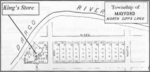
During the 1860s an ancient river bed was worked at varying depths below the basalt of the Dargo Plains. Principal workings were off King's Spur above Mayford where Sinnott and party opened out a face of gravel deposits, then tunnelled into the wash for some distance. The basalt crust of the Dargo and Bogong High Plains was formed by massive volcanic eruptions covering and disturbing the watercourses as they then existed. The present river valleys have formed since the volcanic era leaving the old beds at higher
altitudes. The creeks falling from the Dargo Plains, in which gold has been found, have generally obtained their deposits by cutting through the old leads (or ancient stream beds). It is where these leads have been cut that auriferous gravels may be found on the slopes.
There was little doubt that these high level leads were auriferous throughout; however, the distribution of gold through the great thickness of the leads was such that it could only be profitably mined on a large scale, and with ample water supply for hydraulic sluicing methods.
Across the Dargo valley at Mount Tabletop, Armour & Co. had similar ambitions to Sinnott and so did Morris's party at Boiler Plain. At Brandy Creek on the Cobungra fall were the most successful of the high lead workings known as ‘White's’; which was worked successfully on a larger scale during the 1880s.
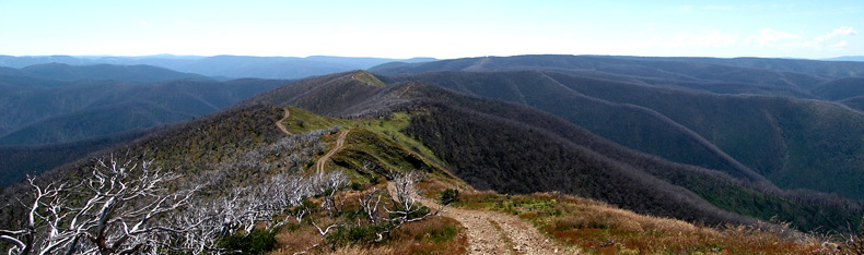
Blue Rag Range Track is a spectacular off road adventure.
Mount Blue Rag is the highest point of the track at an elevation of 1726m above the sea level. There are many excellent photo opportunities. Don't forget your camera with fully charged batteries. Awesome 360 degree views at the summit. We will make a decision at this point whether we continue down to the Wongungarra River.