Meet: Maprun. 2km, 30 minutes, grade 2
Meet: Maprun. 2km, 30 minutes, grade 2
"Hopefully you're still getting out for some exercise. But perhaps you're looking for something different or something to do with the kids?
Good news - you can go orienteering!
Several MapRun (GPS orienteering) courses are available in various locations. You can walk/run/ride the courses at any time and repeat them as you please. More courses will be added in the near future.
A list of courses and downloadable maps are at: https://awoc.org.au/MapRun
Contact me if you have any questions or encounter any problems. And please follow social distancing and other rules as appropriate!
A big thank you to those that have helped with course preparation (Leigh Privett, Raf Freire, Rick Armstrong and Jeff Cave).
As mentioned, we'll add more courses soon - let me know if you're able to help (it's not hard and can potentially be done sitting at home)."
- Peter Mousley AWOC President 0466 166 020 peter@mousley.com.au
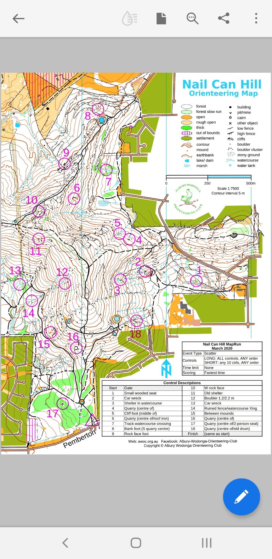
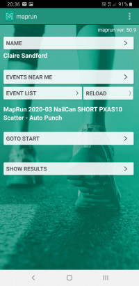
Orienteering with MapRun Nail Can Hill – March 2020 NOTE: While ‘social distancing’ is in place this activity is intended to be completed alone or with those you normally live with – IT IS NOT A GROUP ACTIVITY Orienteering is a sport combining running/walking/riding with navigation. MapRun is a smartphone app that uses the GPS in your phone to track you progress around the course. Instead of ‘punching’ at physical controls, the MapRun app will record your visit and give a ‘beep’ of acknowledgement. At the completion of your course you can check your route, course time and compare your results with others if you wish. MapRun courses can be done at any time and courses can be repeated, allowing you to try different routes. Using MapRun 1. Install the free ‘MapRunF’ App (iOS and Android – note that ‘MapRunF’ supersedes ‘MapRun’). Start the App, read and accept the terms and conditions then tap “NAME” and register your details. 2. Tap “EVENTS NEAR ME” and select the event you want. If you don’t see an event listed then: a/ ensure ‘location services’ are active on your phone OR b/ choose “SELECT EVENT” and navigate to ‘Victoria’, ‘Albury-Wodonga’ and select an event 3. Tap “GOTO START” and the course map will appear, a blue dot will show you current location 4. When ready, go to the start point (triangle on map) and you’re off! 5. When you are finished, tap “SHOW RESULTS” to compare your time with others or your own result from previous attempts. You can also see results on the website: http://maprunners.weebly.com/results.html. Nail Can Hill – March 2020 • This course is based around Nail Can Hill, Albury with the Start/Finish off Pemberton St (use the carpark 100 m south-west of the start location near the intersection with Roper St) • There are two ‘scatter’ courses – LONG (all 18 controls) and SHORT (any 10 controls) ◦ after starting, visit the specified number of controls in ANY ORDER then return to the start/finish point ◦ descriptions of each control are provided on the map ◦ results are determined by the fastest time • A printable map can be downloaded from the link below or scan the QR code Assitance • Email: maprun@awoc.org.au • Phone: 0466 166 020 • MapRun website (see below) Warning: You participate at your own risk and are responsible for your safety. Take care crossing roads, use pedestrian crossings and lights if available. All council rules and by-laws apply. Please respect our beautiful parks! MapRun app and info Local orienteering Course maps and details http://maprunners.weebly.com/ https://awoc.org.au https://awoc.org.au/MapRun
MapRun_2020-03_NailCan_instructions.pdf